Page
11: The
Alaska Highway
The Highway, paved for the first few miles, soon changed to a gravel
surface and, the weather being dry and hot, the going became very
dusty. The road ran for long stretches through the northern boreal
forest with an occasional small town or tiny settlement interrupting
the unvarying trees on both sides. Occasionally, possibly to relieve
the monotony, and perhaps also to keep drivers awake, a grim sign
beside the road identified the location of an accident and indicated
how many people had been killed.
Along
some stretches, large areas of bare, blackened remains of trees revealed
where huge forest fires had swept the land. These desolate areas were
enlivened by brilliant patches of the Yukon's territorial flower,
fireweed, which was familiar to me from its invariable appearance
on the bleak sites of burned, bombed-out buildings in England.
For
one long day's stretch of road, the highway guide recommended that
we carry a spare can of gasoline, as there were no gas stations for
this considerable distance. We saw a moderate amount of traffic -
cars, some of them pulling trailers, and many trucks, large and small,
with and without trailers, in whose dusty wake we were often obliged
to travel.
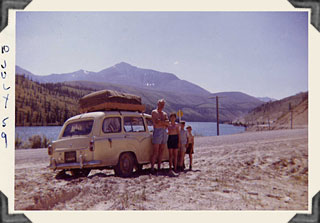
Summit Lake, B.C. Mile 385 (July 10, 1959)
On
July 10 we reached the highest elevation on our route - 4,250 feet
- at Summit Lake. It was a very hot day, and when I took this picture
we had just stopped for a drink of cold water. It was a new and wonderful
experience to drink from a pure stream falling down the rocky mountain
side.
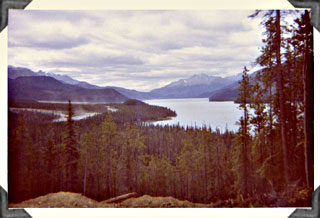
Muncho Lake, B.C., Mile 463 (July 7, 1961)
The
road north proved to be, on the whole, a tedious experience, but occasionally
a particularly spectacular sight relieved the rows and rows of fir
and spruce trees through which we were driving. Muncho Lake, about
150 miles south of the Yukon border, was particularly impressive and
beautiful. It also had a wonderful place in which to pitch our tent
- right on the shore, with an incredible view of the mountains across
the intensely blue lake. The campsite also had some very welcome conveniences
in the form of showers and toilets.
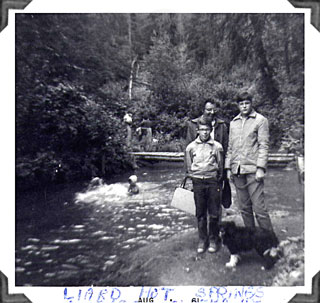
Liard Hot Springs, Mile 497 (1961 photo)
Some
miles further on, at Mile 497, we came to the Liard River hot springs.
The water there was as deliciously warm as it had been in Jasper and
Banff. But these hot springs remained in their natural woodland environment,
in contrast with the elegant buildings and pool structures that had
been built around the springs of the national parks.
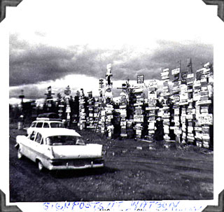
Watson Lake signposts, Mile 644 (August 1961)
Just
north of Lower Post (Mile 620), we passed the B.C./Yukon border on
the sixtieth parallel, arriving at last in Yukon Territory. Quite
soon we reached Watson Lake (Mile 644), where we were surprised to
see a multitude of signposts displaying the distance between Watson
Lake and an amazing number of other places in the world. In 2003 the
signs totalled a fantastic nine thousand - a new and different sort
of northern forest!
Northwest
Highway System Headquarters.
We came to journey's end fifty-three miles after Jake's Corners (Mile
865). Driving past Whitehorse at Mile 918, we at last reached Camp
Takhini, at Mile 931. The camp, a small town in itself, was built
on a stretch of the "clay cliffs" that overlook the town
of Whitehorse. The capital city was visible below us, spread along
the banks of the Yukon River, its larger part on the same side of
the river as Camp Takhini.
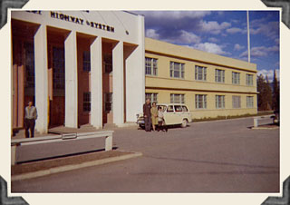
Headquarters Building, Northwest Highway System, Camp Takhini (May
28, 1961)
Dick
reported his arrival at the highway system's Camp Takhini headquarters,
with its impressive entrance. He found his new command, the Signals
Message Centre, on the ground floor to the right of the entrance.
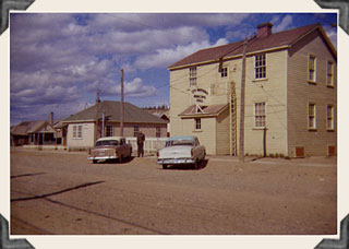
Original Royal Canadian Signals radio station and married quarters,
Whitehorse, Y.T. (May 28, 1961)
[Next
Page]
Pages: [1]
[2] [3]
[4] [5]
[6] [7]
[8] [9]
[10] [11]
[12] [13] [14]
[15] [16]
Return to top of
page
Return to the Watts
Family page